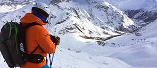
Mount Kato Ski Resort Guide
Mount Kato, United States
| Highest Lift | 165m |
|---|---|
| Resort Height | 91m |
| Nearest Airports | Minneapolis and Chippewa Valley |
Mount Kato
Mount Kato offers diverse terrain and family-friendly amenities. Perfect for enthusiasts of all ages, it's a must-visit winter destination.
Summary
Nestled in Minnesota, Mount Kato features 19 ski runs and a vertical drop of 240 feet, catering to skiers and snowboarders alike. With a blend of beginner and advanced trails, this resort provides a balanced experience for everyone.
The ski area of Mount Kato is at an altitude of 91m.
Mount Kato has direct access to a total of 8 ski lifts.
The skiing is at relatively low altitude, so snow cover can be variable.
Snow and Weather
Mount Kato typically enjoys reliable snow conditions, with an average snowfall of around 50 inches per season. To ensure the best experience, check the latest snow reports on J2Ski before your trip.
When will it snow in Mount Kato?
There is currently no significant snow in the 7-day forecast for Mount Kato.
See our long-range Snow Forecast for the latest update.
Snow this week
| We | Th | Fr | Sa | Su | Mo | Tu |
|---|---|---|---|---|---|---|
Ski Area Stats
Mount Kato Ski Area
| Ski Lifts Number of Lifts | 8 | |
|---|---|---|
Mount Kato Altitudes
| Highest Lift | 165m |
|---|---|
| Lowest Piste | 91m |
| Resort Altitude (Mount Kato) | 91m |
Skiing
Mount Kato spans over 120 acres, with 19 ski runs ranging from gentle beginner slopes to challenging black diamond trails. Key lifts include the Kato Lift and the Jolly Green Giant, providing efficient access to notable pistes like the Kato Cruiser and the Big Kato.
Ski Lessons in Mount Kato
To choose a Ski School, and book Group Ski Lessons or a Private Instructor, see Mount Kato Ski Schools and Mount Kato Ski Instructors.
Snowboarding
Snowboarders will appreciate the terrain parks at Mount Kato, which include the Kato Park and the Family Park. These parks feature various jumps, rails, and boxes suited for all skill levels, allowing for creativity and progression.
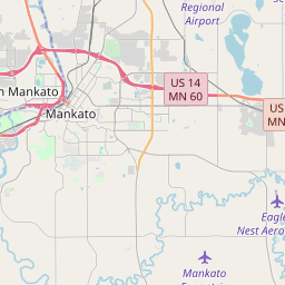
Location and Map
Where is Mount Kato?
This ski resort is in Mankato, Blue Earth, United States.
Map
Tap ![]() for Full-Screen, or see J2Ski's Resort map, showing Hotels and Ski Shops.
for Full-Screen, or see J2Ski's Resort map, showing Hotels and Ski Shops.
How to get there
By Air
The nearest airport to Mount Kato is Minneapolis, 94 minutes drive away.
Chippewa Valley airport is also within three hours drive.
To reach Mount Kato, fly into Minneapolis-St. Paul International Airport, approximately 90 miles away. From there, take I-35W S to US-14 W for a scenic drive to the resort.
Infrastructure
Ski Lift Capacity
The eight ski lifts are able to uplift 14,650 skiers and snowboarders every hour.
Season Dates
When is Mount Kato open?
We don't currently have confirmed season dates, but hope to soon.
NOTE:- Ski area, lift and piste opening is subject to Current Snow Conditions.
Aprés Ski
After a day on the slopes, unwind at the Kato Lodge or the popular Kato Grill. These venues offer a lively atmosphere with delicious meals and refreshing beverages, perfect for relaxing and sharing stories from the day.